Background
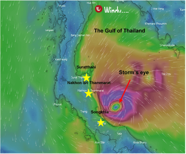
A few days after a New Year’s festival celebration, Thailand’s Meteorological Department reported the incoming tropical storm to hit the Southern Thailand, named “Pabuk”. It was originated in the Southern South China Sea with the maximum wind speed of 65 km/hr or faster. Its name was given after the large fresh water fish in Mekong River by Laos as a member of the World Meteorological Organization Typhoon Committee. The storm is approaching the Gulf of Thailand from the south direction with the speed of 25 km/hr and expected to hit Southern Thailand between 3rd and 5th January. An expert revealed that its moving speed and wind speed are not that fast comparing to the well-known storms in the past, which will result in continuous heavy rainfall and very rough seas for several days.
Due to the location, Thailand has been occasionally affected by serious storms. In the past 30 years, Thailand has encountered 2 destructive storms: “Typhoon Gay” and “Typhoon Linda”. Typhoon Linda hit The Gulf of Thailand in 2540 as a tropical storm with wind speed around 80 km/hr and moved across Thailand to the west side and dissolved in the Bay of Bengal. Typhoon Gay, Thailand’s most severe storm in the last 35 years, started from low pressure air and developed to depression, tropical storm and eventually typhoon just in a few hours. The storm landed at Chumphon on November 4th 1989 with the wind speed around 185 km/hr (Level 3 typhoon) and caused wide range of damage. More than 446 deaths were reported. Pabuk will not be as aggressive as Gay because of the lower wind speed but the damage is still expected to be intense.

Effects and Countermeasures
There will be heavy rainfall and very rough sea which will lead to floods in Pattani, Yala, Pattalung, Songkhla, Nakhon Sri Thammarat, Suratthani and Chumphon and the Andaman side from 3rd January and will be worst on 5th January. Nakhon Sri Thammarat and Suratthani are expected to receive most damage. Some damages have been reported; more than 20 electricity poles in Nakhon Sri Thammarat were collapsed and the electricity blackout was spread to many areas. Since the wind speed has raised to 85 km/hr which could damage constructions such as windows, doors and roofs. Tourists in famous islands such as Koh Tao, Koh Samui and Koh Phangan had to be evacuated. Several closures and cancellations has been reported as follows: Nakhon Sri Thammarat Airport, Moo Koh Similan and Moo Koh Surin National Parks, Raja Ferry Port, Seatran Ferry and Ang Thong National Park (updated January 4th 2019). On January 4th, one death has been reported near Pattani.
Officials has announced a warning and civilians living in the affected areas or expected areas were evacuated, including workers who work at the oil rig in the middle of Gulf of Thailand, but some insisted to stay. However, the prediction of storm’s movement is still uncertain, the situation is still needed to be monitored day to day.
Forecasts
Regarding to forecast from Thailand’s Meteorological Department, Pabuk will move across the Southern Thailand to Andaman Sea from 4th-5th January. As a result, there will be downpour and heavy rain in many locations. The flash flood has to be aware. The waves in both Gulf of Thailand and Andaman Sea will be even more powerful.
Read more flood news at Interrisk’s News Page.
Copyright 2018 MS&AD InterRisk Research & Consulting, Inc. All Rights Reserved