
Thai Flood Report: Forecast of Thailand’s Rainy Season 2018
Summary
As the rainy season has arrived last week, there have been a few flood situations; mostly caused by heavy rainfall but the situations were relieved in not long time. The rainfall in Northern area of the country caused water logged on the road and stream to the village such as in Chiang Mai and Lampang. The water storage levels in main dams are still low as well as the water levels in main rivers and canals.
Forecast
For the rainfall amount forecast in 2018 rainy season, it is expected that the overall rainfall amount will be 5-10% less than normal value and also less than last year’s. By the beginning of the season (June), the rainfall amount will be close to normal value. Then, in the middle of season (July-August), the rainfall will also be close and less than normal value and will be less than normal value in the end of season (September-Middle October). The period with the most amount of rainfall will be in August and September which will also have high probability of tropical storms.
Expected rainfall amount in each region of Thailand
| Area | Expected rainfall amount in rainy season 2018 (mm) | |||||
| May | June | July | August | September | October | |
| Northern | 178 | 156 | 176 | 223 | 218 | 124 |
| Northeastern | 187 | 203 | 211 | 266 | 242 | 117 |
| Central | 172 | 145 | 156 | 181 | 257 | 187 |
| Eastern | 224 | 262 | 278 | 303 | 257 | 187 |
Sothern (Thai Gulf) | 224 | 262 | 278 | 303 | 330 | 255 |
| Sothern (Andaman) | 310 | 312 | 337 | 399 | 424 | 367 |
| Bangkok | 248 | 157 | 175 | 219 | 334 | 292 |
Red cell: 5%-10% higher than normal value
Green cell: close to normal value
Blue cell: 5%-10% lower than normal value
Remarks
-Normal value refers to the average rain fall amount in the past 30 years
The overall amount of rainfall in May and June will be close to the normal level except in the Northern and the Northeastern region because of an influence from the monsoon that moves pass the Northern and Northeastern regions.
Flood events
Flood news during the past weeks: May 16th 2018: Heavy rainfall in Bueng Sub-District of Sriracha District, Chonburi Province caused 50 cm high flood as an influence from the tropical storm. The area has never been flooded before. May 20th 2018: Windstorms hit several provinces causing falling trees and electric posts such as in Chaiyaphum, Phrae and Uttaradit. May 22nd 2018: The water from stream overflowed to the villages in Lampang Province after 5 hours of rainfall. May 24th 2018: Heavy rainfall in the night caused water logged in the village in Muang District of Chiang Mai Province. May 26th 2018: All-night rain in Pang Nga caused flood on Takua Pa-Phuket road which paralyzed the traffic. May 27th 2018: After 2 hours of raining, the flash flood from mountain attacked villages in Phayao Province. June 4th 2018: 30 cm high flood due to heavy rainfall in Khon Kaen and Udonthani Provinces. June 5th 2018: One-hour heavy rainfall in Phuket caused floods on many road surfaces and flowed to the residence areas. It also caused landslides in some areas. June 5th 2018: Heavy rain in Korat caused flood and flashflood to destroy road. This caused paralyzed traffic and car accident. June 9th 2018: Chao Phraya dam increased the drainage rate from 250 m3/s to 350 m3/s to due to the increasing amount of water from the northern region. |
Dam Storage Level (Sirikit Dam, Bhumibol Dam)
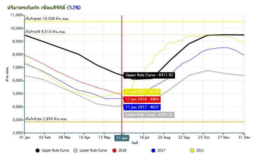
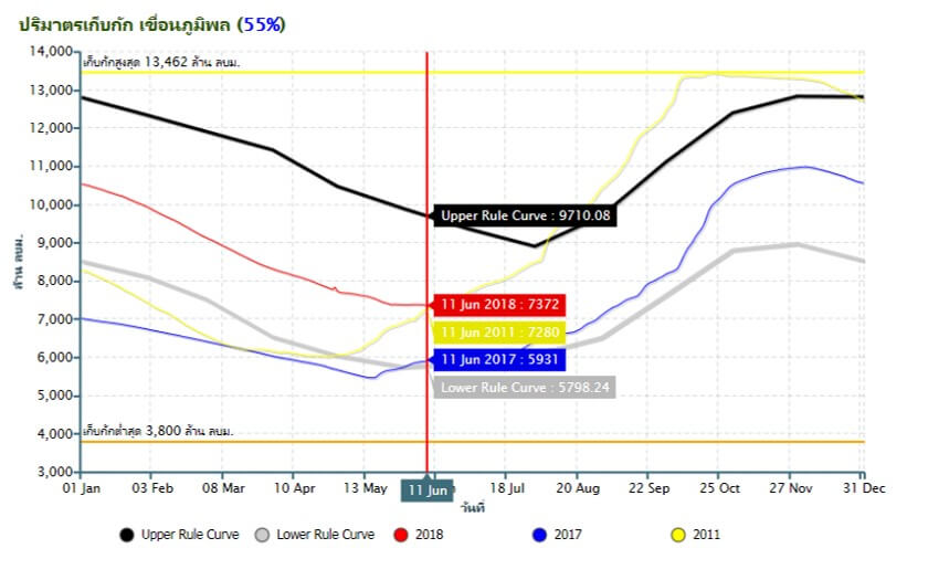
The water storage level in both dams are close to 2011 but higher than last year. Since this period is the beginning of the rainy season, the water storage level will be starting to increase in the next coming months but may not so much as last year.
Dam Storage Level (Pasak Dam, Kwaenoi Dam)
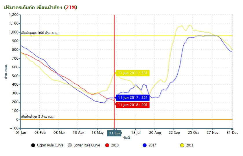
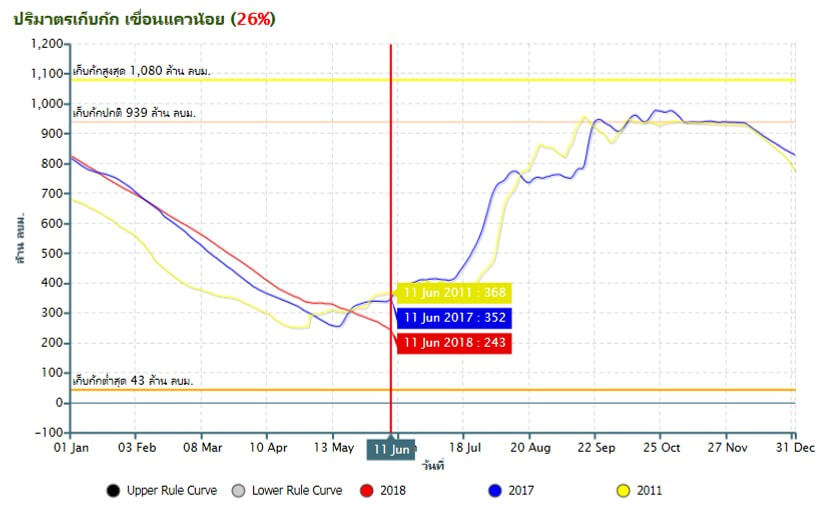
Both dams are now having low water storage level, as the dry season has just ended. Comparing to 2011 and 2017, the water level is very low. The storage level is expected to be higher in the following months.
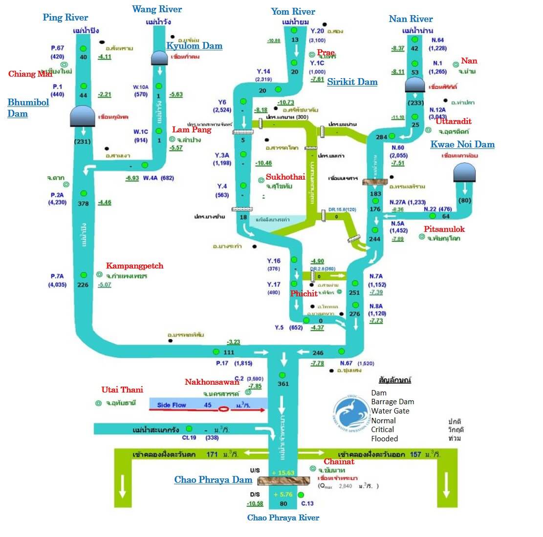
The Upper Chao Phraya River Flow
The water situations in main rivers and canals are at normal level. The current levels are a lot lower than the river bank.
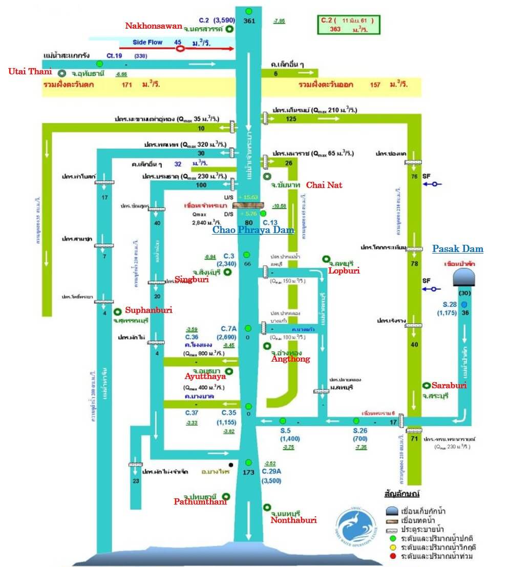
The Lower Chao Phraya River Flow
As the amount of water from the upper Chao Phraya is still low, the amount of water in the lower Chao Phraya is also low, since there has been not much rainfall as the rainy season has just begun.
References
- https://www.tmd.go.th/monthly_forecast.php
- http://www.arcims.tmd.go.th/dailydata/yearRain.php
- http://climate.tmd.go.th/content/file/831
- https://www.thairath.co.th/content/1276647
- https://www.thairath.co.th/content/1282627
- https://www.thairath.co.th/content/1288119
- https://www.thairath.co.th/content/1290271
- http://www.thaiwater.net/DATA/REPORT/php/rid_lgraph3.php?dam_id=19
- http://water.rid.go.th/flood/plan_new/chaophaya/Chao_up.php?cal2=25052018
- http://water.rid.go.th/flood/plan_new/chaophaya/Chao_low.php?cal2=25052018
- http://water.rid.go.th/flood/flood/weekreportnew.pdf
- http://www.arcims.tmd.go.th/dailydata/yearRain.php
- https://www.tmd.go.th/7-day_forecast.php
- http://www.thaiwater.net/DATA/REPORT/php/rid_lgraph3.php?dam_id=19
- http://water.rid.go.th/flood/flood/daily.pdf
- http://water.rid.go.th/flood/plan_new/chaophaya/Chao_up.php?cal2=12062018
- http://water.rid.go.th/flood/plan_new/chaophaya/Chao_low.php?cal2=12062018
- https://www.ryt9.com/s/tpd/2835764
- https://www.ryt9.com/s/iq01/2837021
- https://www.ryt9.com/s/nnd/2839123
- https://www.ryt9.com/s/nnd/2839123
- http://thaiflood.kapook.com/view192788.html