[Summary]
- The rainfall amount from the beginning of July is substantially higher than last year in the south.
- In the first half of July, the quantity and dispersion of rainfall will still be low.
- In the second half of July, there will be rain in many areas and will be heavy in some areas due to the strengthening of the southwest monsoon.
- The storage levels in all major dams of the Chao Phraya Basin are slightly lower than the beginning of June. However, the storage levels are mostly relatively higher than last year.
- The river levels of both upper and lower Chao Phraya River are close to beginning of June and are in normal to low level. There is no concern about flood.
Precipitation
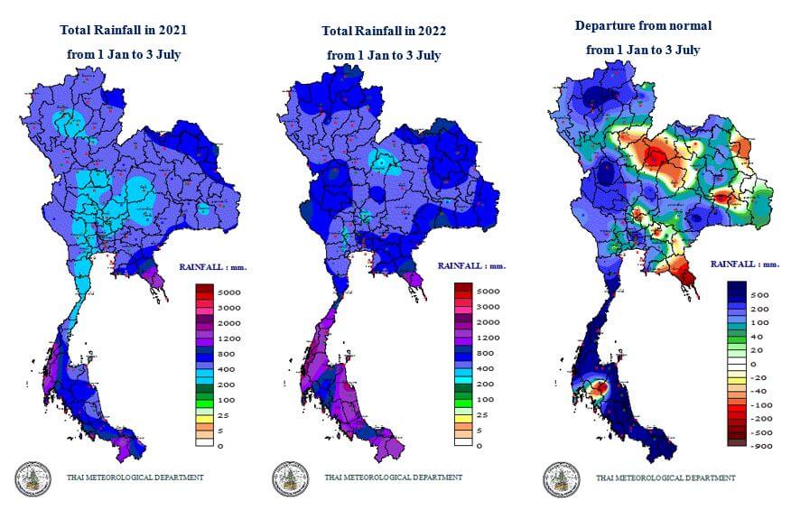
The precipitation until the beginning of July comparing to last year is substantially higher, especially in the south of country. The accumulated rainfall is in the range of 800-2000 mm in the southern area which is the effect from La Nina. If comparing to the average rainfall value, this year’s accumulated rainfall is significantly higher in the north of country and substantially higher in the south of country.
Note: Normal value is the average rainfall amount within the period of 30 years (1981-2010)
Forecast
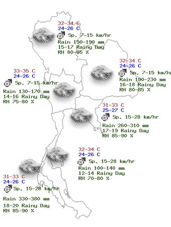
According to the monthly weather forecast from the Thai Meteorological Department, the quantity and dispersion of rainfall will still be low in the first half of July, approximately 20-30 percent of the area. Afterwards, the quantity and dispersion of rainfall will gradually increase in the second half of July. There will be rain in many areas and will be heavy rain in some areas, especially in the eastern region and southwestern region. These are the consequence of the weakening of the southwest monsoon that has been covering the Andaman sea and the country in the first half of the month, and then the southwest monsoon will gradually strengthen. In addition, there will be monsoon trough that will periodically lay along the northern regions in the second half of July.
For the precipitation forecast in July, most of total rainfall will be approximate to the normal value. Except, the total rainfall of northern region and northeast region will be approximately 10 percent lower the normal value.
Caution in July, there will be tropical storms usually formed in the western region of North Pacific Ocean, and moving thru the Philippines into the South China Sea. Thus, the southwest monsoon that has covered the Andaman sea and the country will strengthen, as a result, rain will be increased, especially in southwest region and eastern region coasts.
Note: Normal value is the average rainfall amount within the period of 30 years (1981-2010)
Dam Storage Level (Sirikit Dam, Bhumibol Dam)
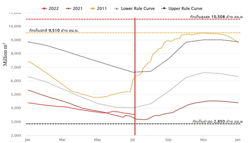
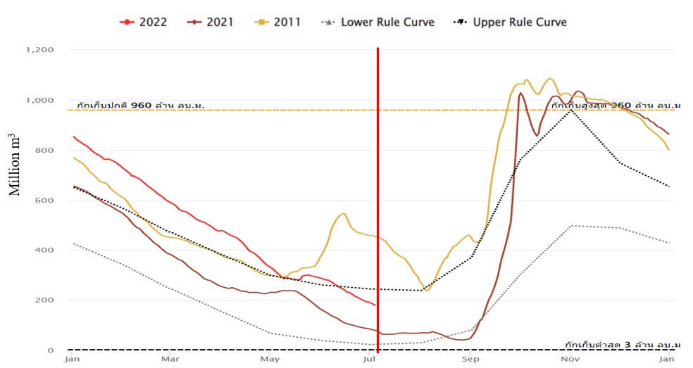
Storage level Sirikit Dam (37%) 4 July 2022
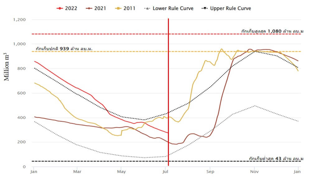
Storage level Bhumibol Dam (42%) 4 July 2022
The storage level of Sirikit Dam until July 4th is slightly higher than last year although the storage level at the beginning of the year is low. For Bhumibol Dam, the storage level is relatively higher than last year. Despite a higher rainfall, both dams are in decreasing trend which are totally different from 2011.
Dam Storage Level (Pasak Dam, Kwaenoi Dam)
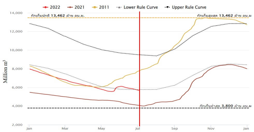
Storage level Pasak Dam (19%) 4 July 2022
Storage level Kwaenoi Dam (29%) 4 July 2022
The storage levels of both Kwaenoi Dam and Pasak Dam comparing to the beginning of the year are substantially lower. However, the storage levels are slightly higher than the last year.
The Upper Chao Phraya River Flow
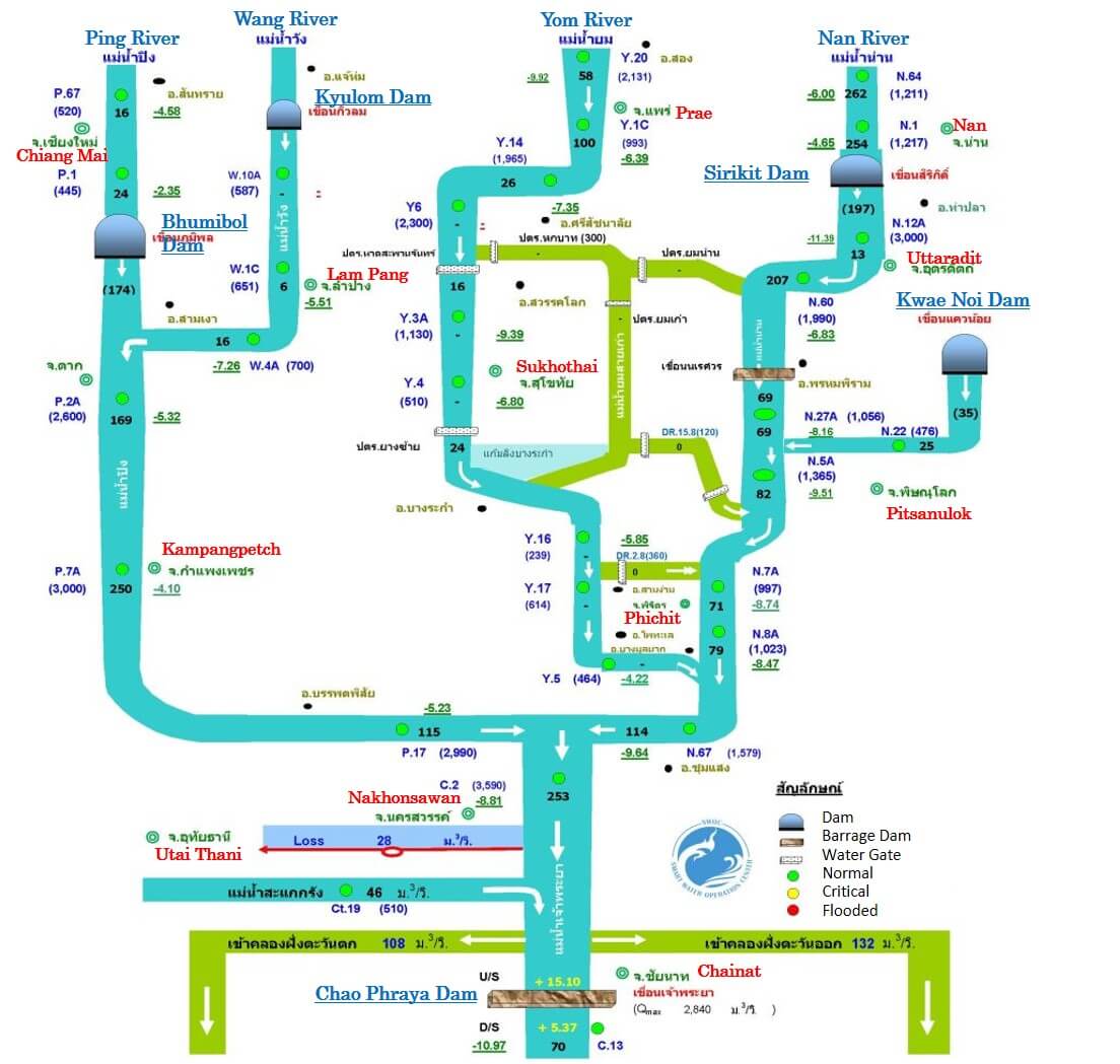
The river levels in Ping, Wang, Yom and Nan are close to the beginning of June. The river level of the Chao Phraya River above the Chao Phraya Dam is considerably lower than the bank. Thus, there is no critical situation regarding flood event.
Water Situation in the Chao Phraya River
4th July 2022
Note: – Numbers in bracket indicate the flow rate of water in m3/sec.
– Numbers with underline indicate higher (+) or lower (-) of water level than the river bank in meters.
– Water levels U/S and D/S are in meters.
The Lower Chao Phraya River Flow
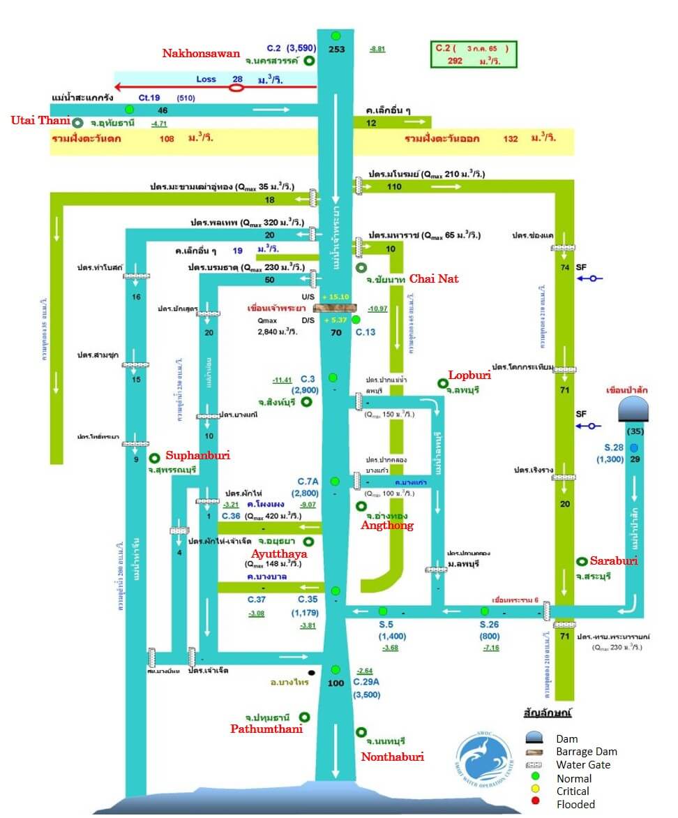
The river levels in Lower Chao Phraya are close to the beginning of June. The river level is clearly lower than the river bank. There is no notable situation.
Water Situation in the Chao Phraya River
4th July 2022
Note: – Numbers in black indicate the flow rate of water in m3/sec.
– Numbers in bracket the flow rate of water in m3/day.
– Numbers with underline indicate higher (+) or lower (-) of water level than the river bank in meters.
References
- http://www.arcims.tmd.go.th/dailydata/yearRain.php
https://www.tmd.go.th/monthly_forecast.php - https://www.thaiwater.net/water/dam/large
- http://water.rid.go.th/flood/plan_new/chaophaya/Chao_up.php?cal2=04072022
- http://water.rid.go.th/flood/plan_new/chaophaya/Chao_up.php?cal2=03062022
- http://water.rid.go.th/flood/plan_new/chaophaya/Chao_low.php?cal2=04072022
- http://water.rid.go.th/flood/plan_new/chaophaya/Chao_low.php?cal2=03062022
__________________________________________________________________________________________________________
MS&AD InterRisk Research & Consulting, Inc. is a MS&AD Insurance Group company specialized in risk management survey research and consulting services. For inquiry about consultation and seminar etc. for companies expanding business in Thailand, please feel free to contact the nearest Mitsui Sumitomo Insurance or Aioi Nissay Dowa Insurance sales representatives.
MS&AD InterRisk Research & Consulting, Inc.
International Section, Corporate Planning Department
TEL.03-5296-8920
http://www.irric.co.jp
__________________________________________________________________________________________________________
InterRisk Asia (Thailand) is a MS&AD Insurance Group company which was established in Thailand to provide risk management services, such as fire safety, flood risk management, electrical safety and risk consulting services, such as automotive risk assessment, occupational safety and burglary risk survey to our clients in Thailand. For inquiry, please feel free to contact us.
InterRisk Asia (Thailand) Co., Ltd.
175 Sathorn City Tower, South Sathorn Road, Thungmahamek, Sathorn, Bangkok, 10120, Thailand
TEL: +66-(0)-2679-5276
FAX: +66-(0)-2679-5278
https://www.interriskthai.co.th/
__________________________________________________________________________________________________________
