
[Summary]
- Comparing to the same period of last year (2022), the rainfall amount of this year is significantly lower especially in the upper country.
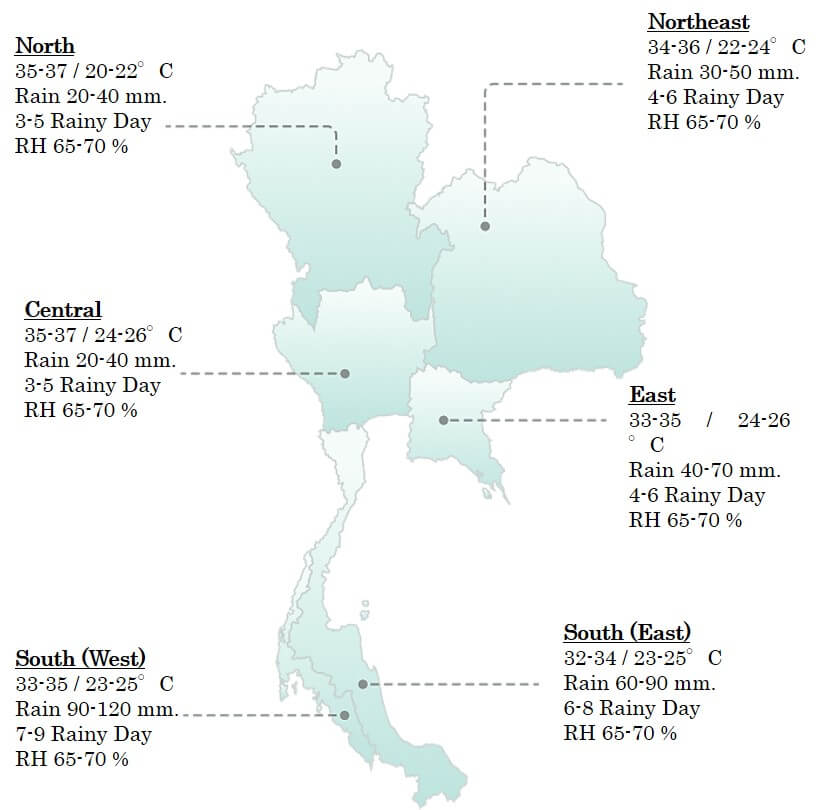
- The weather in March will be mostly hot in overall country and there will be partial rainfall which is the effect from the southwest monsoon wind.
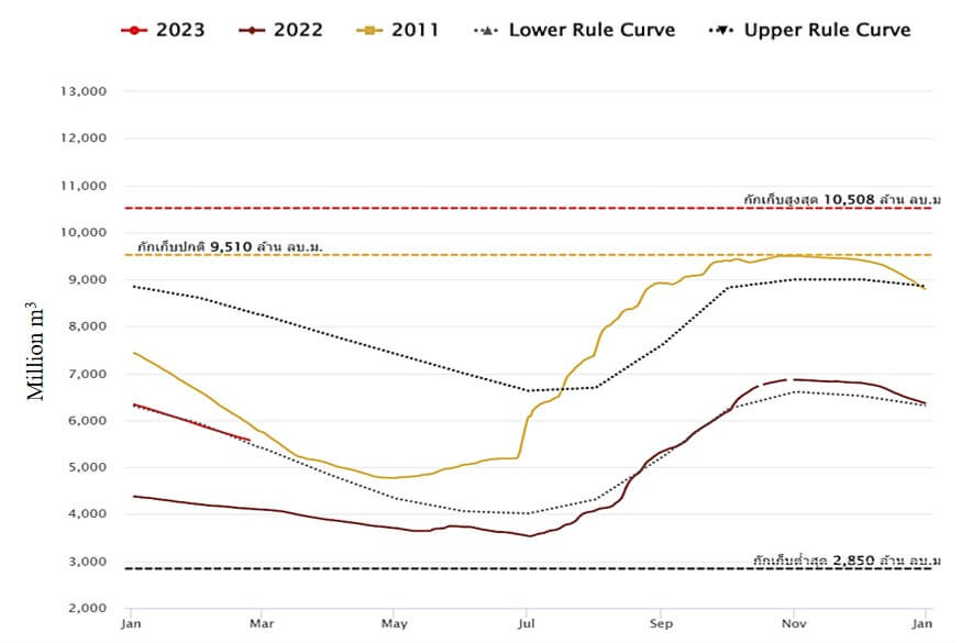
- All main dams in Chao Phraya River Basin are in the decreasing trend. The storage level in Sirikit Dam is higher than last year (2022) and slightly lower than 2011 but the storage level of Bhumibol Dam is higher than both 2011 and 2022.
- There are no concerning topics in the main rivers and canals of the Chao Phraya River Basin. The river levels are mostly in low level.
Precipitation
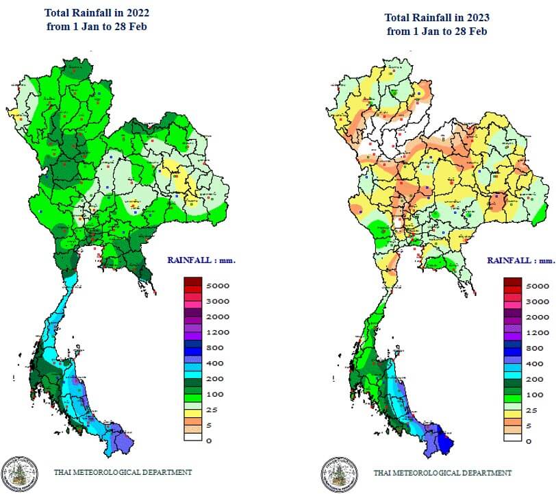
Comparing to 2022, the total rainfall from January 1st until February 28th of this year is significantly lower especially in the upper country. The total rainfall in the upper country is in the range of 50 to 200 mm, whereas in this year, the total rainfall in the upper country is mostly in the range of 5 to 50 mm.
Forecast
In March, the weather in the first half of the month will be hot at times and will be hot in overall country. The highest temperature would reach 40-43 ˚C in many areas especially in the upper country. However, there will be the occasional coverage of the southwest monsoon wind which will result in periodical rainfall. Overall, the average temperature is close to normal value and the rainfall amount is slightly lower than normal value.
Water Management in 2023
Prapit Janma, the Director of the Royal Irrigation Department (RID), had reported that the RID had followed the 13 rainy season water management measures in 2022. There are machinery and equipment support such as water drainage pumps in total of 2,260 units in 58 provinces that had been affected by flood. The water budget in all country after the rainy season (November 1st) is at 64,000 million m3 which 5,495 million m3 greater than in 2021. For this year’s water management for drought season, 43,740 million m3 of water is prepared which 14,074 million m3 is arranged in four main dams for the Chao Phraya River Basin, 9,100 million m3 (62%) is arranged for the drought season and 5,474 million3 (38%) is reserved for the beginning of rainy season.
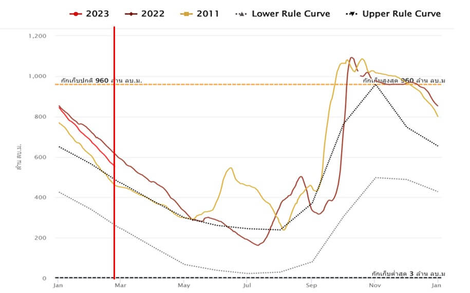
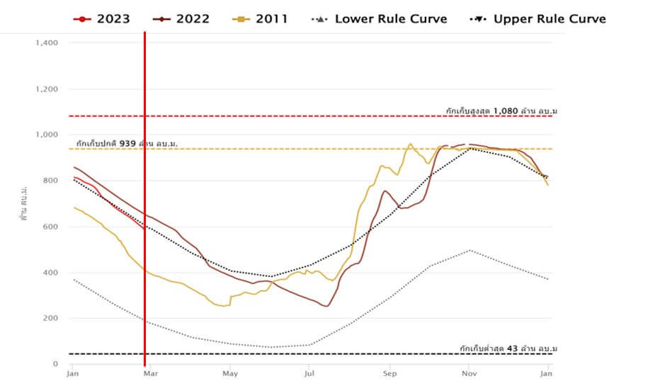
Dam Storage Level (Sirikit Dam, Bhumibol Dam)
Storage level Sirikit Dam (58%, 28 Feb)
Storage level Bhumibol Dam (75%, 28 Feb)
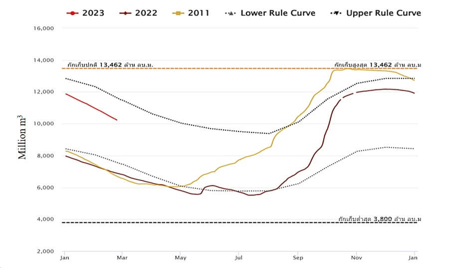
Current Sirikit dam storage levels is slightly lower than in the same period of 2011 when the great flood occurred. On the other hand, the storage level of Bhumibol Dam is substantially higher than both 2011 and 2022. Both dams are in the decreasing trends.
Dam Storage Level (Pasak Dam, Kwaenoi Dam)
Storage level Pasak Dam (55%, 28 Feb)
Storage level Kwaenoi Dam (60%, 28 Feb)
Both Pasak Dam and Kwaenoi Dam are relatively in the same trend as the storage levels are lower than 2022 but higher than 2011. Both dams are also in the deceasing trend.
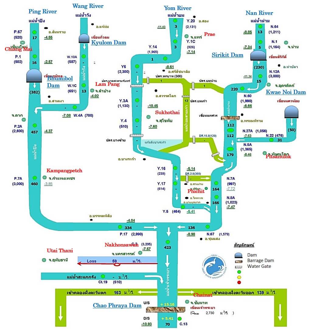
The Upper Chao Phraya River Flow
The river levels in Ping, Wang, Yom and Nan Rivers are mostly in low level. For example, the water level in Nan River at Nan, Pitsanulok and Nakhon Sawan is 7-8 lower than the river banks. The river level of the Chao Phraya River over the Chao Phraya Dam is approximately the same as last month (January).
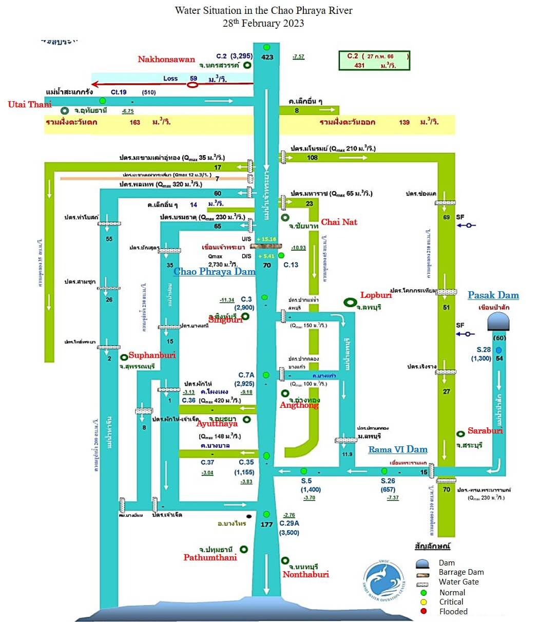
Water Situation in the Chao Phraya River
28th February 2023
Note: – Numbers in bracket indicate the flow rate of water in m3/sec.
– Numbers with underline indicate higher (+) or lower (-) of water level than the river bank in meters.
– Water levels U/S and D/S are in meters.
The Lower Chao Phraya River Flow
The flow rate of the Chao Phraya River below the Chao Phraya Dam is approximately the same as January (70 m3/sec) comparing to the rainy season at higher than 800 m3/sec. There are no concerning situations in the lower Chao Phraya River.
Water Situation in the Chao Phraya River
28th February 2023
Note: – Numbers in black indicate the flow rate of water in m3/sec.
– Numbers in bracket the flow rate of water in m3/day.
– Numbers with underline indicate higher (+) or lower (-) of water level than the river bank in meters.
References
- http://www.arcims.tmd.go.th/dailydata/yearRain.php
- https://www.tmd.go.th/forecast/monthly
- http://water.rid.go.th/flood/flood/daily.pdf
https://www1.rid.go.th/index.php/th/2019-04-26-19-42-45/1473-30-01-2566 - https://www3.tmd.go.th/media/forecast-threemonthcountry/newsjfm_2023.pdf
- https://www.thaiwater.net/water/dam/large
- http://water.rid.go.th/flood/plan_new/chaophaya/Chao_up.php?cal2=24022023
- http://water.rid.go.th/flood/plan_new/chaophaya/Chao_low.php?cal2=24022023