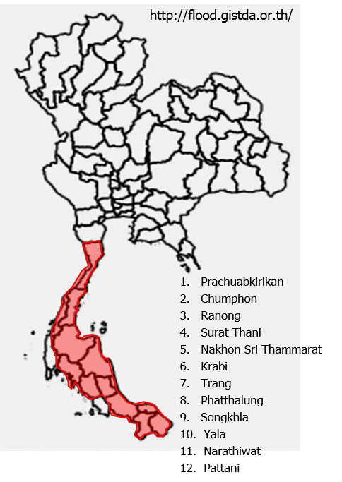
InterRisk Thai Flood Report
Summary
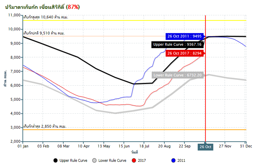
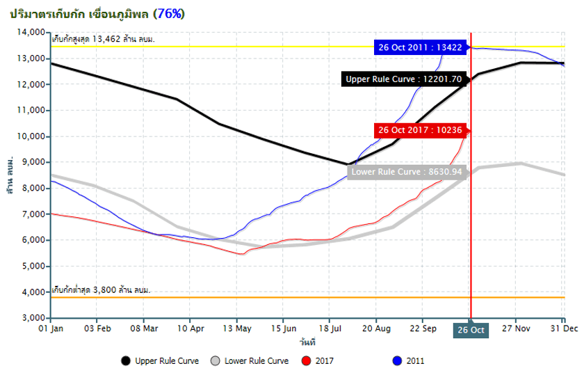
According to TMD, the amount of rainfall since January is about 1,700 mm which is above the average at 1,572 mm. Consequently, there have been flood situations in many parts of the country, especially in the riverside areas and provinces in the north and northeast areas. Currently, the water levels in the main dams are critical in many areas such as Pasak dam and Kwae Noi dam that the capacity is almost at their full capacity.
In conclusion, the Chao Phraya dam and Pa Sak dam increase the drainage rate, causing the water level of lower Chaophraya river to increase and overflow in some areas of Nonthaburi, Pathumthani and Ayutthaya. Moreover, the inundated water in the retention areas almost reaches 95% of the maximum capacity. The situation needs to be monitored.
Government announcements
Since there has been large amount of rain above Chao Phyara dam, causing the drainage to be increased from 2,600 m3/sec to 2,700 m3/sec and would be at this rate for a week. The drained water from Chao Phraya dam would cause 20-25 higher water level in the under dam areas for a short period of time. Moreover, the Minister has ordered the RID to prepare for possibly incoming flood situations in the southern region.
Thai Meteorological Department announced that the overall rain tended to reduce in the northern and northeastern region which was considered a good sign, especially at the Chao Phraya dam.
Flood events:
20th Oct: Nakhon Sawan municipal urgently reinforce the flood protection dyke on the side of Chao Phraya river.
22th Oct: Chao Phraya river overflowed to the riverside villages in Pathumthani due to the coming water from
Chao Phraya dam.
23th Oct: Chao Phraya dam increased water drainage to 2,700 m3/sec to help relieve flood situation in above-dam
areas.
24th Oct: Heavy rain in Doi Inthanon caused flash flood in many districts of Chiang Mai.
24th Oct: 40-60cm increasing of Chao Phraya river level caused the water to overflow to Pak Kred, Nonthaburi.
24th Oct: Water overflowed to Sena District of Ayutthaya after “Jao Jed” flood gate had been damaged.
24th Oct: Chao Phraya river overflowed to Nonthaburi city near Bang Kwang prison.
Situation: Nonthaburi Flood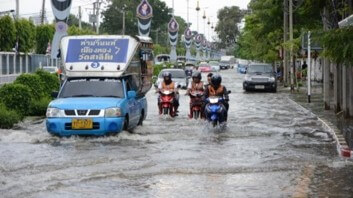
Increased the water level from Chaophraya dam has caused Nonthaburi province to
become flooded. Some premises next to Chaophraya River has become flooded 30-40 cm
and some street is now flooded and traffic is blocked. Currently estimated 100 houses
are affected.
Situation: High Tide has passed
According to TMD water tide is now on the decreasing tide. The highest peak was on 8th Oct and gradually reduced. Water discharge rate of major river would be increased from now on.
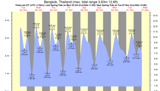
However, the overall water discharge from local premise would depend on the amount of water management and drainage capacity to the major water source. It is important to concern the water discharge rate out of the premise and make sure that the flood protection is fully functional.
Water Level in Major Dam
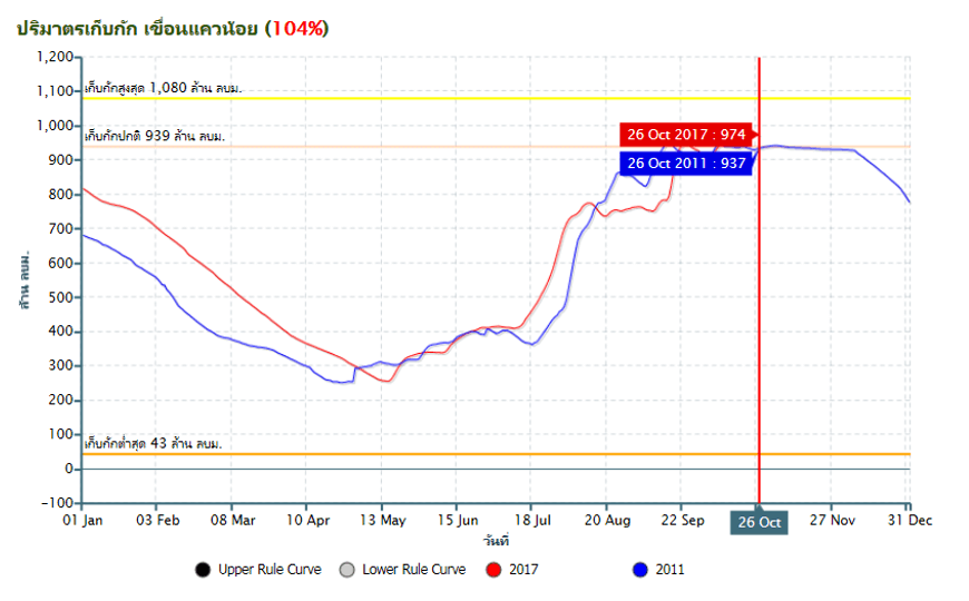
Increasing water from Pasak Dam
On 25th October Pasak dam has announce to increase water release rate from 25 million m3 to 30 million m3 which intern will increase water level in Chaophraya River by 20-30 cm. In addition to amount of increasing Chaophraya Dam water flow. The premises near the river should be cautious about the situation.
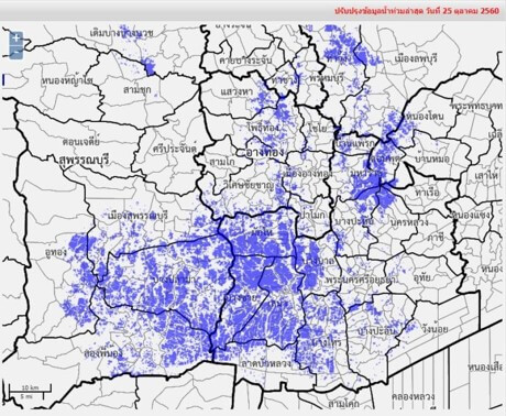
Inundated water in water retention area near maximum
Water in water retention area (Ayutthaya, Suphanburi) has reached 95% or 1,300 million m3. This amount of water is under irrigation department management. However, Irrigation department plans to divert the inundated water to the sea. It would takes about 30-45 days to release the water to the normal level.
2017: High amount of Rainfall
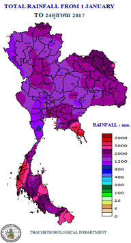
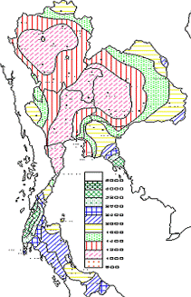
According to TMD the amount of rainfall in 2017 is more than average at 1,700 mm where the average country is 1572 mm. according to the reference the amount of yearly rainwater in 2011 is at 1,781mm The water is under irrigation department management which is diverted to canals and water retention areas (monkey cheek). In this regards, if the water management fails, the flood similar to 2011 could occurs due to the amount of rainfall. It is important to inspect and ensure that the flood protection and management is reliable and fully functional.
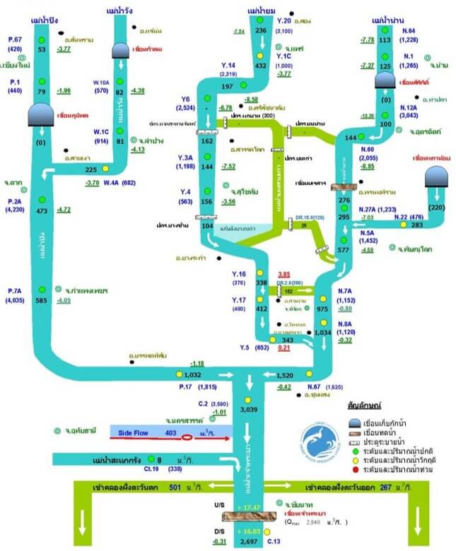
The Upper Chao Phraya River Flow
The amount of water from Upper Chaophraya has increased and spread to wider area but still under its capacity in most area. The critical area is in Phichit area where Yom and Nan river adjoins. In addition to Chainat area. However, the situation is same as last month. The amount of water increased largely came from Ping and Wang river. The amount of water at Chao Phraya river dam has increased from 2,600 m3/s to 2,700 m3/s. Premises near Chaophraya River should be aware of the situation.
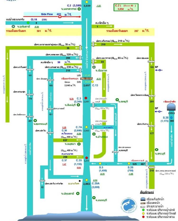
The Lower Chao Phraya River Flow
The amount of water from Upper Chaophraya has contiously increased. Many area has been flooded in Singburi and Chaophraya. Water in many area is also at critical level. In case of heavy rainfall, the drainage from land to the major river could be reduced and resulted in inland flood. It is necessary to check the drainage capacity and the ability to drain water to major rivers.
References
https://www.tmd.go.th/7-day_forecast.php
http://water.rid.go.th/flood/plan_new/chaophaya/Chao_low.php?cal2=25102017
http://water.rid.go.th/flood/plan_new/planup.html
http://water.rid.go.th/flood/plan_new/chaophaya/
http://www.thaiwater.net/DATA/REPORT/php/rid_lgraph3.php?dam_id=19